Concept
Hydrological models are essential tools for simulating the movement and distribution of water across the Earth’s surface and subsurface. These models represent physical hydrological processes such as river discharge, surface runoff, infiltration, evapotranspiration, snow accumulation and melt, and groundwater flow. Simulating these processes in models helps us understand and predict water availability under current and future conditions.
FutureWater specializes in process-based hydrological modelling to support water resource assessments, climate impact studies, and hydrological forecasting. We employ open-source hydrological models such as HEC-RAS and SWAT or our in-house developed Spatial Processes in Hydrology (refer to SPHY). The results of these models are frequently integrated with water allocation and planning models (refer to Water Allocation and Planning/WEAP) to link water availability with the supply-demand side of the water resources system. Our approach combines remote sensing data, in-situ observations, and climate reanalysis products to improve the model’s accuracy and spatial representation.
For over 20 years, FutureWater has provided expertise to intergovernmental institutions, government and research agencies, private companies, and non-governmental organizations, to help understand and manage water resources under a changing climate.
FutureWater Applications
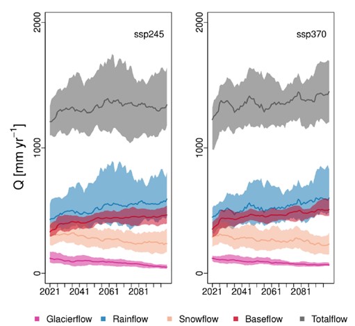
FutureWater applies data-driven and process-based modelling to quantify hydrological processes at multiple spatial and temporal scales. One of our main focus areas is climate change impact assessments. In these analyses, we analyze how shifts in temperature and precipitation patterns resulting from climate change affect hydrological systems. Changes in climate influence river flows, groundwater recharge, and the frequency of extreme events such as floods and droughts. By integrating hydrological models with climate projections, we provide insights into future water availability and risks, helping decision-makers develop adaptive strategies for sustainable water management.

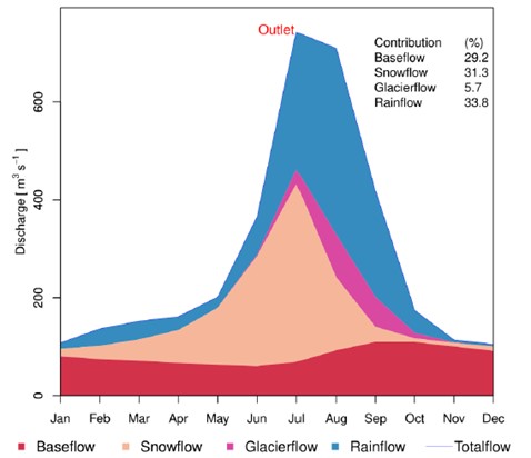
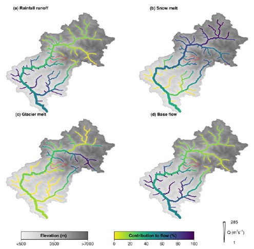
Many river basins depend on snow and glacier melt as a key water source. We study seasonal snow accumulation and melt dynamics to estimate their contribution to river flows. By integrating satellite data and in-situ measurements we improve the accuracy of snow and glacier runoff simulations. This knowledge is crucial for water management in mountainous regions such as the Himalayas, where significant amounts of water are stored as snow and glaciers.


