The MRC’s State of the Basin Report (SOBR) is a flagship product of the organization and an integral part of the MRC’s strategic planning cycle. Compiled about every five years based on the available data and information, the report assesses conditions and trends within the basin and the impacts that development and use of water and related natural resources are having. The SOBR provides a statement of past trends and current conditions, and seeks to highlight and provide guidance to Member Countries on significant transboundary issues that require cooperation among basin countries to address. The SOBR 2023 is structured around the Mekong River Basin Indicator Framework, consisting of 5 dimensions: Environment, Social, Economic, Climate Change, and Cooperation.
As a longstanding collaborator of MRCS, FutureWater was engaged to support the development of the Economic and Climate Change chapters of the SOBR 2023 and perform the related activities of data analyses, advisory on data gaps and SOBR content, attractive presentation of key results, and communication with Member Countries and specialized MRCS staff to address their comments and suggestions.
The issue of water scarcity is intensifying across the Asia Pacific region, posing significant challenges for sustainable agricultural production and water resources management. The Water Scarcity Program (WSP), designed by FAO-RAP and partners, aims to bring agricultural water use within sustainable limits and prepare the sector for a productive future with less water. The program aims to assess the ongoing issue of water scarcity in the region, evaluate potential management options, and assist partner countries to implement adaptive management in the agriculture water sector using innovative tools and approaches.
As part of the WSP, FutureWater will design and deliver a two-phase water accounting training program in Indonesia, Vietnam and Thailand, respectively. The first phase of the training will primarily focus on introducing and better understanding the concept of water accounting, its components and approaches. Participants will also work with tools such as REWAS and Follow the Water (developed by FutureWater in collaboration with FAO) to conduct water accounting in agricultural systems at different scales. Through the use of these tools, participants will be able to estimate real water savings at system and basin scale, and also analyze the impact of different irrigation schemes on the overall water availability in the system. The second phase will consist of participants working on the selected basin in each country to develop a detailed water account. Given the data availability and accessibility issues in the region, the participants will learn how to access, process and analyse remotely sensed datasets using Google Earth Engine.
In addition to the trainings, FutureWater will also provide technical inputs for the regional WSP events on water scarcity and highlight the technical challenges of implemeting water accounting and allocation in south-east Asia for the WSP High Level Technical Meeting to be held in June 2024.
The Mekong State Of the Basin Report (SOBR) is published by the Mekong River Commission (MRC) every five years, in advance of the cyclic updating of the Basin Development Strategy. The SOBR plays a key role in improving monitoring and communication of conditions in the Mekong Basin, and is MRC’s flagship knowledge and impact monitoring product. It provides information on the status and trends of water and related resources in the Mekong Basin. The 2023 SOBR is based on the MRC Indicator Framework of strategic and assessment indicators and supporting monitoring parameters, which facilitates tracking and analysis of economic, social, environmental, climate change and cooperation trends in the basin.
FutureWater was hired by MRC to perform the following tasks in support of the 2023 SOBR development:
Data collection on the Extent of Salinity intrusion in the Mekong Delta and the conditions of the Mekong River’s riverine, estuarine, and coastal habitats
Analyses of the extents of 2010, 2015, and 2020 LMB wetlands
Analyses of the extents of key fisheries habitat areas in the LMB, and
Data collection for all Assessment Indicators of MRB-IF for the Upper Mekong River Basin (UMB), including reporting and extracting key messages
Implementation of tasks 1 – 3 is achieved by using state-of-the-art remote sensing tools, such as the Google Earth Engine, building on the methods developed in the preceding project.
Task 4 builds on the findings of FutureWater’s contribution to the 2018 SOBR regarding the status of the UMB in China and Myanmar, more details can be found here.
The MRCS regularly undertakes periodic regional and basin-wide studies on behalf of Member Countries to assess potential effects of increasing development, growing population and uncertainty in climate variability in the Lower Mekong Basin (LMB). Recent basin-wide assessment and reporting were found to be hampered by data limitations across a range of areas. With the basin undergoing rapid and extensive change, tracking changes in conditions, analyzing the potential implications, and working cooperatively to leverage the benefits and avoid the problems are seen as critical to achieving the objectives of the 1995 Mekong Agreement.
To provide a greater strategic direction to the monitoring and assessment effort, the Mekong River Basin Indicator Framework (MRB-IF) was developed and approved aiming at providing a consistent and streamlined approach to data collection, analysis, and reporting. Through the MRB-IF, the MRC Member Countries and stakeholders can be alerted to the key issues and trends across five core dimensions (environment, social, economic, climate change and cooperation). Included in the MRB-IF are (i) the extent of salinity intrusion in the Mekong Delta (MD) – Assessment Indicator 14 and (ii) the condition of riverine, estuarine, and coastal habitats – Assessment Indicator 16. A systematic process of collection and analysis of the data for status and trends evaluation regarding these indicators is currently missing.
The aim of this project is therefore to develop a basin-specific systematic approach to periodically assess the extent of salinity intrusion in the Mekong Delta and the conditions of the riverine, estuarine, and coastal habitats across the LMB. Methodologies to evaluate both indicators are developed relying on integration of satellite remote sensing data, GIS databases, and station data. The project involves an elaborate review of existing methodologies tested in the LMB and other river basins, an assessment of these methods regarding technical, economic and institutional aspects, and the development of a recommended methodology for adoption by MRCS, including guidance documentation for its stepwise implementation.
In irrigated agriculture options to save water tend to focus on improved irrigation techniques such as drip and sprinkler irrigation. These irrigation techniques are promoted as legitimate means of increasing water efficiency and “saving water” for other uses (such as domestic use and the environment). However, a growing body of evidence, including a key report by FAO (Perry and Steduto, 2017) shows that in most cases, water “savings” at field scale translate into an increase in water consumption at system and basin scale. Yet despite the growing and irrefutable body of evidence, false “water savings” technologies continue to be promoted, subsidized and implemented as a solution to water scarcity in agriculture.
The goal is to stop false “water savings” technologies to be promoted, subsidized and implemented. To achieve this, it is important to quantify the hydrologic impacts of any new investment or policy in the water sector. Normally, irrigation engineers and planners are trained to look at field scale efficiencies or irrigation system efficiencies at the most. Also, many of the tools used by irrigation engineers are field scale oriented (e.g. FAO AquaCrop model). The serious consequences of these actions are to worsen water scarcity, increase vulnerability to drought, and threaten food security.
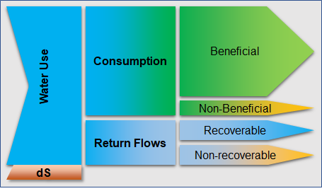
There is an urgent need to develop simple and pragmatic tools that can evaluate the impact of field scale crop-water interventions at larger scales (e.g. irrigation systems and basins). Although basin scale hydrological models exist, many of these are either overly complex and unable to be used by practitioners, or not specifically designed for the upscaling from field interventions to basin scale impacts. Moreover, achieving results from the widely-used FAO models such as AquaCrop into a basin-wide impact model is time-consuming, complex and expensive. Therefore, FutureWater is developing a simple but robust tool to enhance usability and reach, transparency, transferability in data input and output. The tool is based on proven concepts of water productivity, water accounting and the appropriate water terminology, as promoted by FAO globally (FAO, 2013). Hence, the water use is separated in consumptive use, non-consumptive use, and change in storage (see Figure).
A complete training package is developed which includes a training manual and an inventory of possible field level interventions. The training manual includes the following aspects: 1) introduce and present the real water savings tool, 2) Describe the theory underlying the tool and demonstrating some typical applications, 3) Learn how-to prepare the data required for the tool for your own area of interest, 4) Learn when real water savings occur at system and basin scale with field interventions.
Emerging markets and low-income countries continue to need large investments in infrastructure to remove constraints on growth; create job opportunities; respond to urbanization pressures; and meet crucial development, inclusion, and environmental goals. In 2009, ADB estimated that an infrastructure investment of $8 trillion would be required during 2010–2020 to maintain current levels of growth in Asia.
Infrastructure for transport and communications, energy generation and transmission, and the supply of water and sanitation are critical for development. These types of infrastructure usually have long service lives, which renders both the region’s existing infrastructure stocks and its future infrastructure investments vulnerable to changes in climate conditions that may take place in the near and medium terms. One of five overarching reasons for concern cited by the fifth assessment report of the Intergovernmental Panel on Climate Change in 2014 was the existence of systemic risks “due to extreme weather events leading to breakdown of infrastructure networks and critical services such as electricity, water supply, and health and emergency services.”
The Technical Assistance study focusses on “building climate change resilience in Asia’s critical infrastructure”. The expected impact of the study is scaled-up support for effective climate change adaptation. The expected outcome of will be an enhanced knowledge base on climate change risks to critical infrastructure in South Asia and Southeast Asia. Specifically, by the end of the study it is expected that Asian Development Bank (ADB) and its Development Member Countries (DMC) will have a fuller understanding of the actions and innovation needed to make critical infrastructure in South Asia and Southeast Asia more resilient to climate change.
The study will focus on 11 countries in South and South-East Asia with three countries in specific: Indonesia, Sri Lanka and Vietnam.
Climate change is likely to pose major challenges for the Lower Mekong Basin (LMB). Therefore, information on climate change, its impact and climate change adaptation are required to enable decision-making to develop and implement appropriate response measures. A monitoring and reporting system on climate change and adaptation can help to track changes and to store relevant data for assessing status and impacts of climate change in the LMB for supporting adaptation planning.
With this study, the Climate Change Adaptation Initiative (CCAI) of the Mekong River Commission (MRC) offers a review of existing monitoring systems and indicators to improve the understanding of riparian governments, relevant line agencies and others on the status and impacts of climate change. The report should inform the establishment of a database and monitoring system by the CCAI, to build knowledge on climate change and adaptation in the LMB and support information to other activities of the CCAI and MRC programmes.
The review suggests indicators to measure climate exposure, climate impact and climate adaptation activities within the LMB focusing on the thematic areas hydrology, land, agriculture, fisheries, biodiversity, hydropower, food security, and poverty as well as employment. Based on this comprehensive review, recommendations are developed on how to improve baseline data and the sharing of data, what tools are needed for the establishment of the basin wide CCAI monitoring system and what capacity building activities can be useful to this end.
In 2011 the Vietnamese and Dutch government signed a Memorandum of Understanding on the establishment of a Government to Government (G2G) programme for improved integrated planning and monitoring of water resources for transboundary water management and disaster risk management. Special attention within this cooperation is given to the use of remote sensing and Geographical Information Systems (GIS) for improved monitoring and modelling of (transboundary) water resources. The current project was formulated as part of the G2G trajectory towards implementation of an operational decision support system for water resource management and disaster risk management at the Ministry of Natural Resources and Environment (MoNRE).
With the infrastructure to be developed, information services based on remote sensing, models and ground observations can be delivered to end users in a clear and visually attractive way. Its functionality will be demonstrated with a pilot project on Basin-wide Multipurpose Reservoir Management (BMRM) for the Da River. The scope of the project is explained in the below figure. The parts with solid lines (e.g. remote sensing, ground data) will be part of this project. A Delft-FEWS platform is implemented that manages the dataflow from Remote Sensing or ground data as well to ensure that available models will run with up-to-date data. Furthermore, a visualization tool is developed for selected end-users.
The main foreseen project results include:
Infrastructure for integrated water management and disaster risk management implemented at NRSD.
Integrated model ensemble (hydrological, hydraulic and reservoir) installed in the infrastructure and ready for operation by NRSD.
Model for creating daily rainfall maps installed in the infrastructure and ready for operation by NRSD.
Knowledge transferred on operating and managing the infrastructure and using the implemented models.
First steps taken towards Cooperation between institutions of Vietnam in sharing and applying new technologies in optimizing data acquisition, access to data, and use of data standards.
FutureWater is the leader of the work package on data collection and validation, and will implement its SPHY model for simulating Da River basin hydrology and inflow to reservoirs.