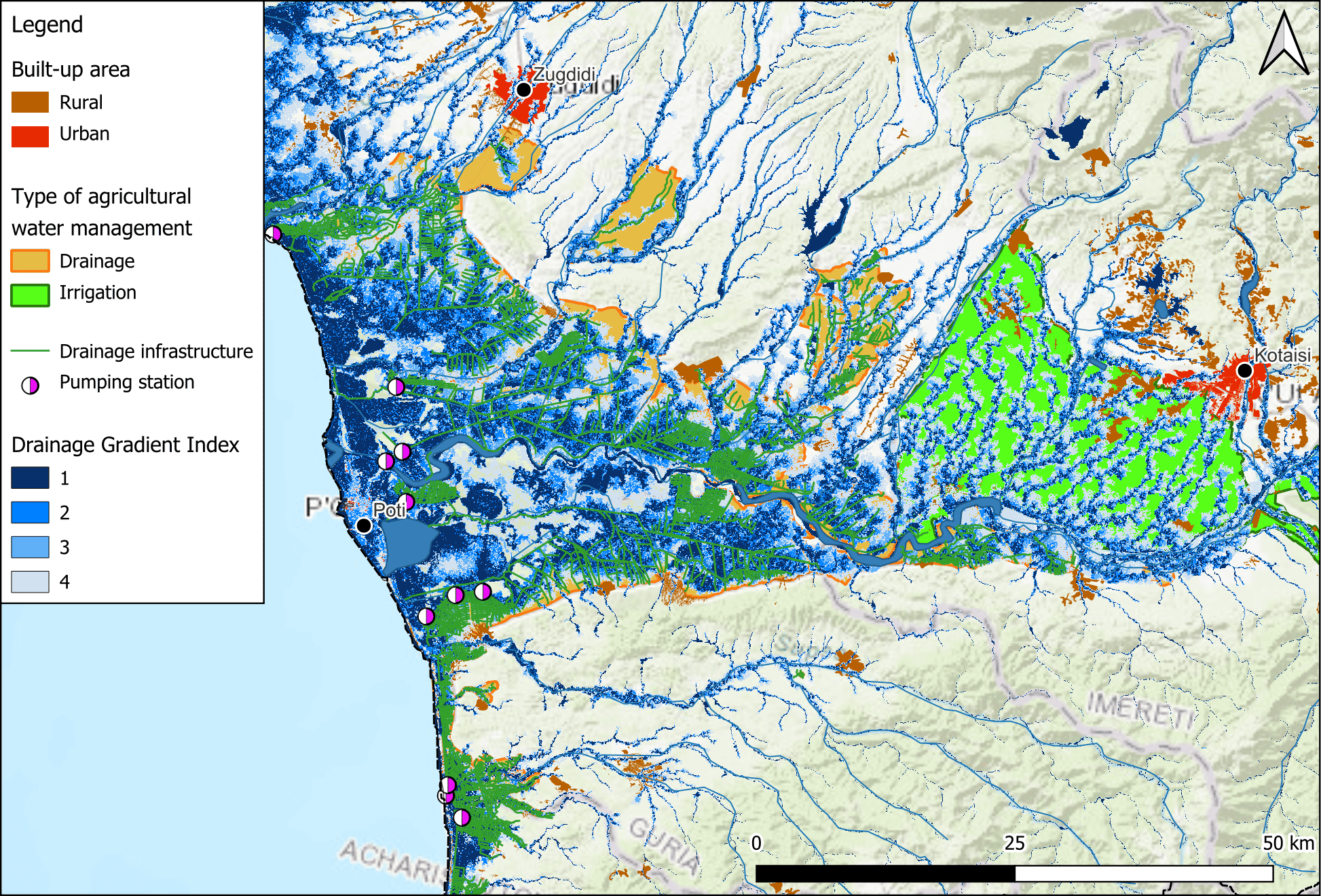
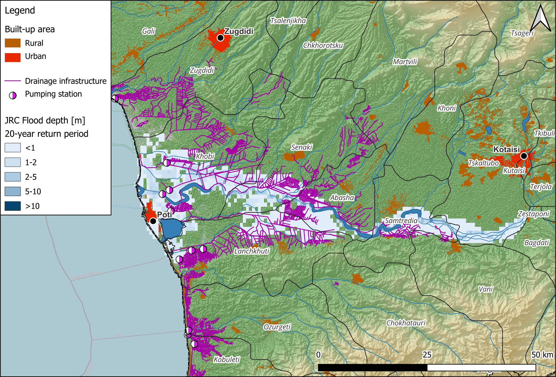
The WEFE NEXUS International Conference, themed “Exploring and Bridging Nexus for a Sustainable Future,” was held on 11-12 February 2025 at the Institut Agronomique et Vétérinaire Hassan II in Rabat, Morocco. Jointly organized by the BONEX and SureNexus projects, both funded by PRIMA, this important event convened a diverse group of researchers, policymakers, entrepreneurs, and practitioners from across the globe to tackle the growing challenges and opportunities presented by the Water-Energy-Food-Environment (WEFE) Nexus.
Day 1 focused on governance and gender equity within the WEFE Nexus:
Governance & Policy Integration – Strategies to enhance resilience in resource management.
Gender & WEFE Nexus – Emphasizing gender inclusivity in sustainable development
Day 2 explored innovative solutions for implementing WEFE Nexus strategies:
Trade-off Analysis & Policy Integration – Lessons from multi-country case studies.
Decision-Support Systems – Smart governance for sustainable resource use.
WEFE 2.0 – Redefining sustainability through innovation.
On day 2, FutureWater (Johannes Hunink) presented the Rapid Evaluation for WEFe nexus analysis (REWEFe) tool, and its application several case studies of the BONEX project. The conference fostered collaboration amongst partners in the Mediterranean. Several concrete activities were discussed for Jordan, amongst others. The discussions initiated will continue shaping policies and projects beyond this event.
Presentation of ReWEFePanel Discussion
The international research project on Megadroughts in Europe’s Watertowers (project acronym MegaWat) officially launched with a kickoff meeting at the Institute of Science and Technology Austria (ISTA) the 4th and 5th September 2024.
The meeting brought together all project partners to discuss the research framework, methodologies, and collaborative goals. This project has received funding from the Water4All programme with co-funding from CDTI (Spanish Office for Science and Technology) and the EU’s Horizon Europe Framework Programme for Research and Innovation.
This ambitious project aims to advance the understanding of past and future megadroughts by integrating high-resolution climate reconstructions, tree-ring data, and hydroclimatic modeling. Researchers from Spain (FutureWater), Austria, Switzerland, Netherlands, and other countries, will work together to assess the frequency, drivers, and impacts of extreme drought events.
The kickoff meeting fostered interdisciplinary exchange, setting the foundation for effective collaboration over the coming years. With a strong focus on historical data and future projections, the project seeks to provide valuable insights for water resource management and climate resilience in a changing world.
Acknowledgements
This project has received funding from the Water4All programme with co-funding from CDTI (Spanish Office for Science and Technology) and the EU’s Horizon Europe Framework Programme for Research and Innovation.
Early July, an Asian Development Bank (ADB) delegation and FutureWater visited Ashgabat for meetings and consultations with specialists from Turkmenistan’s Ministries of Agriculture and Environmental Protection, as well as the State Committee of Water Resources. The goal was to establish scientific and practical cooperation for a new climate adaptation-focused project.
The proposed project focuses on greening agricultural production and environmental management. It will include:
• Strengthening institutional and legislative processes
• Measures to adapt to climate change
• Mitigation strategies (reducing greenhouse gas emissions)
• Digitalization in the water sector
• Promotion of space technologies
FutureWater is mapping climate-related hazards and climate vulnerability factors, in order to select focus areas and priority actions.
Following consultations, a consolidated meeting defined the project’s preliminary content. This incorporates presentations by ADB representatives and proposals from Turkmen government officials regarding natural resource protection and use. The project structure will involve three parts: monitoring and modelling; implementation of activities; knowledge capacity building in modern practices.
ADB climate specialist Leo Kris Palao and consultant Johannes Hunink emphasized the importance of a practical and specific approach to maximize the partnership’s effectiveness. Turkmen representatives highlighted the ADB’s history of supporting domestic environmental management practices. They noted previous successful joint projects in nature conservation, food production, and agriculture.
More information about the project can be found here.
Specialists from Turkmenistan discuss identified climate risks and adaptation options with ADB experts and FutureWater (Johannes Hunink)
Het meest recente onderzoek heeft zich gericht op het identificeren van historische megadroogtes op basis van paleo-gegevens en het begrijpen van hun klimatologische oorzaken, of op de studie van “moderne” gebeurtenissen en hun impact, meestal in laagland- en vlakke regio’s. Hooggebergteregio’s en sneeuwafhankelijke stroomgebieden zijn echter weinig bestudeerd, en er is weinig bekend over de impact van megadroogtes op de toestand en dynamiek van de cryosfeer in bergwatertorens.
Over het algemeen hebben stroomgebieden die afhankelijk zijn van hooggebergtesystemen een intrinsieke capaciteit om het gebrek aan neerslag en overmatige evapotranspiratie te bufferen, afhankelijk van de waterreserves opgeslagen in de cryosfeer (sneeuw, gletsjers en permafrost). Er wordt aangenomen dat deze buffercapaciteit beperkt is tot een kantelpunt wordt bereikt, waarna de impact van watertekorten en temperatuur-extremen kan worden versterkt en het functioneren van ecosystemen en watersystemen in gevaar kan brengen.
MegaWat heeft een dubbele doelstelling: 1) het aanpakken van kennisgebreken over de hydroklimatologische oorzaken van extreme droogtes en hun impact op de waterbalans van de bergwatertorens van Europa, met speciale nadruk op het samenvallen van samengestelde gebeurtenissen en cascade- en multischaleffecten, en 2) het ontwikkelen en voorstellen van nieuwe adaptatiestrategieën om om te gaan met de duur, omvang en ernst van toekomstige megadroogtes en hun potentiële impact op milieu- en sociaaleconomische activa.
Voor de uitvoering richt MegaWat zich op de hooggebergteregio’s van Europa en hun afhankelijke stroomgebieden. MegaWat streeft naar de ontwikkeling van drie producten:
Product 1. Een methodologisch kader voor de identificatie en karakterisering van historische megadroogtes tijdens de instrumentele periode, en de beoordeling van de rol van de cryosfeer bij het ondersteunen van de landschapsontwikkeling van stroomafwaartse gebieden, of bij het bufferen van klimaatveranderingseffecten. Product 1 is gebaseerd op een combinatie van klimaatregionalisatie, modellering van de oppervlakte-energiebalans, hydrologische simulatie en analyse van waterevaluatie en -toewijzing op stroomgebiedniveau (zie onderstaande figuur).
Product 2. Een hoog-resolutie, open-toegang, geregionaliseerde klimaatdatabase.
Product 3. Een lijst van potentiële adaptatiestrategieën die nuttig zijn voor de preventie en mitigatie van droogteeffecten, en voor de versterking van de waterveiligheid en veerkracht van hooggebergteregio’s en afhankelijke stroomgebieden. Deze scenario’s worden overeengekomen met regionale en lokale actoren en belanghebbenden, en hun effectiviteit wordt geëvalueerd onder extreme droogtescenario’s in drie pilotregio’s in Europa. Deze pilotregio’s worden vooraf geselecteerd op basis van criteria van representativiteit, strategisch belang en kwetsbaarheid voor droogtes.
Schematische weergave van een hooggebergtebekken, inclusief de belangrijkste componenten, processen en effecten gerelateerd aan droogtes.
FutureWater speelt een belangrijke rol in MegaWat door het coördineren van het werkpakket dat tot doel heeft simulatie-instrumenten te ontwikkelen en te testen die helpen bij de aanpassing aan megadroogtes en het ondersteunen van het besluitvormingsproces. Twee specifieke doelstellingen worden nagestreefd in dit werkpakket: a) de ontwikkeling van een methodologisch prototype voor het kwantificeren van impacten en het identificeren van kantelpunten voor waterveiligheid in sneeuwafhankelijke stroomafwaartse stroomgebieden, en b) de generatie en integratie van sneeuwdroogte-indicatoren in het Drought Early Warning System van FutureWater, genaamd InfoSequia (zie onderstaande figuur).
Workflow van het InfoSequia Early Warning System ontwikkeld door FutureWater en aangepast voor de detectie van kantelpunten van watertekort in sneeuwafhankelijke stroomgebieden. Meer informatie over InfoSequia.
Dit project heeft financiering ontvangen van het Water4All-programma met cofinanciering van CDTI (Spaanse Dienst voor Wetenschap en Technologie) en het Horizon Europe-kaderprogramma van de EU voor onderzoek en innovatie.
For the aspects of Integrated Water Resources Management (IWRM) in Uttarakhand, the SCA-Himalayas project mandated a consortium of international and national level expert agencies led by FutureWater, together with Utrecht University, University of Geneva and TERI – The Energy and Resources Institute to develop a Glacio-Hydrological Model and IWRM Plan for Bhagirathi basin in Uttarakhand.
As part of the project, river runoff for Bhagirathi River has been projected upto year 2100 and different water availability scenarios have been developed. To address the challenges related to the water sector in the basin, an IWRM plan has been developed with the active engagement of all key stakeholders through meetings and consultations. Also, training programmes have been organized for the state officials on glacio-hydrolological and water allocation modelling.
The immersive training programme was conducted on the state-of-art Water Evaluation and Planning System (WEAP) modelling by the international experts. All the trainees were awarded with a completion certificate the session.
This workshop and training programme were envisaged to present the final outputs under the initiative and discuss the ways towards effective implementation of IWRM plan in the Bhagirathi River basin.
The aim is to develop a business case for a Watershed Investment Program for Addis Ababa. It includes stakeholder and governance analysis, scientific modeling, return on investment (ROI) analysis, and an implementation plan. Hydrological models are employed to assess the potential of Nature-based Solutions to mitigate the negative trends in the watershed, and improve water supply reliability, water quality, sedimentation and agricultural productivity. The study should raise awareness for all key stakeholders and potential investors. The study is performed under the Nature for Water Facility launched by The Nature Conservancy.
Southern Spain is a highly productive agricultural region, but with huge challenges around water scarcity and environmental sustainability. There is a demand in the agricultural sector to work towards water stewardship in Spain. The Alliance for Water Stewardship has developed a Standard which helps retailers and their suppliers to cause change at scale. This approach recognizes that there are common challenges that could be more easily overcome through a collective, place-based approach.
In the Doñana region, berry farms and groundwater usage are causing a conflict with the unique ecosystems in the National Park. A catchment assessment and active stakeholder engagement is needed as a first step in this region to work towards water stewardship. The catchment assessment will provide information on the catchment context, in line with the requirements of the Standard. The purpose of the assessment is to reduce the burden on agricultural sites by providing them with a common set of information which they and others can use to inform responses to their shared water challenges.
FutureWater will develop a high-level climate change and adaptation assessment for Turkmenistan to strengthen the water and agriculture sector’s resilience against climate change. The work involves a detailed hazard mapping exercise, employing observational and satellite-based information, to identify climate-related risks such as droughts, water scarcity, heat, salinity, erosion, and floods. These mapped hazards will be synthesized at the administrative level, presenting a comprehensive visual representation through figures and tables.
Key exposure and vulnerability datasets will be mapped, and pertinent sources for subsequent collection and analysis will be identified, setting the stage for a detailed risk assessment beyond the scope of work. The key output of this effort is the assembly of an inventory of climate adaptation measures gleaned from existing reports and official documents, contextualized to Turkmenistan’s unique circumstances, and an initial gap and opportunity assessment based on this inventory.
Based on the assessment, the adaptation options will be categorized and an initial prioritization will take place based on each option’s potential to mitigate risks across various hazards, its capacity for impactful outcomes beyond local scales, and a relative indication of expected cost-effectiveness. The outcome should provide a foundation for an integrated climate adaptation project. Concurrently, FutureWater will engage in country consultations, collaborating with stakeholders to confirm or refine identified adaptation options. These consultations will also explore potential synergies with ongoing and planned projects initiated by both the government and development partners.
Together with the Asian Development Bank, FutureWater visited and consulted ministries and other stakeholders in Tbilisi, Georgia. The objective was to get buy-in on the approach, present preliminary results, and identify gaps and scope for expanding the climate change assessment. Initial ideas on possible adaptation portfolios were presented, and priorities were discussed. The next step is to create a concept note of an adaptation-focused investment project that takes an integrated and catchment-based approach.
Georgia is considered a water-rich country, but facing increasing water shortages and environmental challenges, with high potential to restore and preserve ecosystems, like wetlands, forests and grasslands, as well as to strengthen the country´s capacity to produce sustainable food and energy. More on our work here.
FutureWater supports Fiera Comox in its due diligence process for the acquisition of a vertically integrated tree-fruit operation in North Spain. Particularly, FutureWater addresses an overall assessment of the most important water-related factors of risk that may control the current and medium-term feasibility of the fruit orchard farming system of interest. The application of FutureWater’s approach applies a multicriteria analysis and allows to qualify the levels of risk for each key factor analyzed.
FutureWater’s approach rests on: 1) the collection and analysis of data retrieved from documents, large datasets, and in-situ field inspections and stakeholder interviews, and 2) the scoring of the risks previously identified based on a final expert judgment.
Key sources of information for this risk screening included:
Existing documentation, reports, plans, and local legislation that may affect the access to water for irrigation
Existing and publicly accessible spatial and GIS data, including satellite imagery and thematic datasets available through national and regional agencies and platforms (Ebro River Basin Authority, National Infrastructure of Geospatial Data, Spanish Information System of Water)
Meteorological data (rainfall and temperature) from nearby weather stations
Groundwater level from the Spanish National Ministry of Environment.
Private data and documents generated by clients and stakeholders through personal and follow-up communications with farmer
Key variables analyzed and evaluated at the district and regional scales, to the extent relevant to the farm, included:
Water availability of surface and groundwater resources. For groundwater, a trend analysis of water levels, and first-order assessment of quality constraints and risks is included.
Impacts of climate change on water resources availability based on rainfall and temperature trends and projections for the region.
Water quality for irrigation purposes.
Potential conflicts due to competition for water in agriculture and other sectors of activity.
Legislative and policy-related factors that may affect the overall performance were also analyzed risk-by-risk.
Four factors of risk were analyzed: water availability, climate change, water quality, and water conflict. Each factor of risk was scored according to a risk matrix in which levels of probability of occurrence and impact severity were qualified based on data and expert judgement. For each factor, a risk matrix with three levels of overall risk were adopted: Low Risk (L), Moderate Risk (M), and High Risk (H)
Figure 1. Overall risk levels when probability of occurrence and impact severity are qualified.Figure 2. Overview of risk assessment by factor.
In this particular project, the approach was implemented in four different settings located in the area.