The international research project on Megadroughts in Europe’s Watertowers (project acronym MegaWat) officially launched with a kickoff meeting at the Institute of Science and Technology Austria (ISTA) the 4th and 5th September 2024.
The meeting brought together all project partners to discuss the research framework, methodologies, and collaborative goals. This project has received funding from the Water4All programme with co-funding from CDTI (Spanish Office for Science and Technology) and the EU’s Horizon Europe Framework Programme for Research and Innovation.
This ambitious project aims to advance the understanding of past and future megadroughts by integrating high-resolution climate reconstructions, tree-ring data, and hydroclimatic modeling. Researchers from Spain (FutureWater), Austria, Switzerland, Netherlands, and other countries, will work together to assess the frequency, drivers, and impacts of extreme drought events.
The kickoff meeting fostered interdisciplinary exchange, setting the foundation for effective collaboration over the coming years. With a strong focus on historical data and future projections, the project seeks to provide valuable insights for water resource management and climate resilience in a changing world.
Acknowledgements
This project has received funding from the Water4All programme with co-funding from CDTI (Spanish Office for Science and Technology) and the EU’s Horizon Europe Framework Programme for Research and Innovation.
Het meest recente onderzoek heeft zich gericht op het identificeren van historische megadroogtes op basis van paleo-gegevens en het begrijpen van hun klimatologische oorzaken, of op de studie van “moderne” gebeurtenissen en hun impact, meestal in laagland- en vlakke regio’s. Hooggebergteregio’s en sneeuwafhankelijke stroomgebieden zijn echter weinig bestudeerd, en er is weinig bekend over de impact van megadroogtes op de toestand en dynamiek van de cryosfeer in bergwatertorens.
Over het algemeen hebben stroomgebieden die afhankelijk zijn van hooggebergtesystemen een intrinsieke capaciteit om het gebrek aan neerslag en overmatige evapotranspiratie te bufferen, afhankelijk van de waterreserves opgeslagen in de cryosfeer (sneeuw, gletsjers en permafrost). Er wordt aangenomen dat deze buffercapaciteit beperkt is tot een kantelpunt wordt bereikt, waarna de impact van watertekorten en temperatuur-extremen kan worden versterkt en het functioneren van ecosystemen en watersystemen in gevaar kan brengen.
MegaWat heeft een dubbele doelstelling: 1) het aanpakken van kennisgebreken over de hydroklimatologische oorzaken van extreme droogtes en hun impact op de waterbalans van de bergwatertorens van Europa, met speciale nadruk op het samenvallen van samengestelde gebeurtenissen en cascade- en multischaleffecten, en 2) het ontwikkelen en voorstellen van nieuwe adaptatiestrategieën om om te gaan met de duur, omvang en ernst van toekomstige megadroogtes en hun potentiële impact op milieu- en sociaaleconomische activa.
Voor de uitvoering richt MegaWat zich op de hooggebergteregio’s van Europa en hun afhankelijke stroomgebieden. MegaWat streeft naar de ontwikkeling van drie producten:
Product 1. Een methodologisch kader voor de identificatie en karakterisering van historische megadroogtes tijdens de instrumentele periode, en de beoordeling van de rol van de cryosfeer bij het ondersteunen van de landschapsontwikkeling van stroomafwaartse gebieden, of bij het bufferen van klimaatveranderingseffecten. Product 1 is gebaseerd op een combinatie van klimaatregionalisatie, modellering van de oppervlakte-energiebalans, hydrologische simulatie en analyse van waterevaluatie en -toewijzing op stroomgebiedniveau (zie onderstaande figuur).
Product 2. Een hoog-resolutie, open-toegang, geregionaliseerde klimaatdatabase.
Product 3. Een lijst van potentiële adaptatiestrategieën die nuttig zijn voor de preventie en mitigatie van droogteeffecten, en voor de versterking van de waterveiligheid en veerkracht van hooggebergteregio’s en afhankelijke stroomgebieden. Deze scenario’s worden overeengekomen met regionale en lokale actoren en belanghebbenden, en hun effectiviteit wordt geëvalueerd onder extreme droogtescenario’s in drie pilotregio’s in Europa. Deze pilotregio’s worden vooraf geselecteerd op basis van criteria van representativiteit, strategisch belang en kwetsbaarheid voor droogtes.
Schematische weergave van een hooggebergtebekken, inclusief de belangrijkste componenten, processen en effecten gerelateerd aan droogtes.
FutureWater speelt een belangrijke rol in MegaWat door het coördineren van het werkpakket dat tot doel heeft simulatie-instrumenten te ontwikkelen en te testen die helpen bij de aanpassing aan megadroogtes en het ondersteunen van het besluitvormingsproces. Twee specifieke doelstellingen worden nagestreefd in dit werkpakket: a) de ontwikkeling van een methodologisch prototype voor het kwantificeren van impacten en het identificeren van kantelpunten voor waterveiligheid in sneeuwafhankelijke stroomafwaartse stroomgebieden, en b) de generatie en integratie van sneeuwdroogte-indicatoren in het Drought Early Warning System van FutureWater, genaamd InfoSequia (zie onderstaande figuur).
Workflow van het InfoSequia Early Warning System ontwikkeld door FutureWater en aangepast voor de detectie van kantelpunten van watertekort in sneeuwafhankelijke stroomgebieden. Meer informatie over InfoSequia.
Dit project heeft financiering ontvangen van het Water4All-programma met cofinanciering van CDTI (Spaanse Dienst voor Wetenschap en Technologie) en het Horizon Europe-kaderprogramma van de EU voor onderzoek en innovatie.
Analysis of the historical climate data and future model projections indicates significant shifts in rainfall patterns. These shifts could influence water availability within the upstream river basins, which are vital for irrigation practices and ecological balance. Furthermore, the study explores variations in temperature -including average, minimum, and maximum values- and evaluates their potential consequences on water demand due to increased evaporation rates and altered crop water needs.
Additionally, this scoping research touches upon the effects of these climatic factors on olive crop phenology and productivity. The study also considers the likelihood of extreme weather events, such as heatwaves and droughts, and their potential to disrupt traditional farming cycles and water resource management strategies.
The outcomes of this analysis are aimed at providing an olive producing firm with insights and strategies to mitigate the adverse effects of climate change on olive production in these targeted regions of Andalucia. By foreseeing potential challenges and preparing for them, a decision can be made on whether to invest or not in order to maintain a leading olive producer on the global stage.
Southern Spain is a highly productive agricultural region, but with huge challenges around water scarcity and environmental sustainability. There is a demand in the agricultural sector to work towards water stewardship in Spain. The Alliance for Water Stewardship has developed a Standard which helps retailers and their suppliers to cause change at scale. This approach recognizes that there are common challenges that could be more easily overcome through a collective, place-based approach.
In the Doñana region, berry farms and groundwater usage are causing a conflict with the unique ecosystems in the National Park. A catchment assessment and active stakeholder engagement is needed as a first step in this region to work towards water stewardship. The catchment assessment will provide information on the catchment context, in line with the requirements of the Standard. The purpose of the assessment is to reduce the burden on agricultural sites by providing them with a common set of information which they and others can use to inform responses to their shared water challenges.
This consultancy project is framed by the AQUIFER project, “Innovative instruments for the integrated management of groundwater in a context of increasing scarcity of water resources” (Interreg-SUDOE V programme) which aims to capitalize, test, disseminate and transfer innovative practices for the preservation, monitoring and integrated management of aquifers.
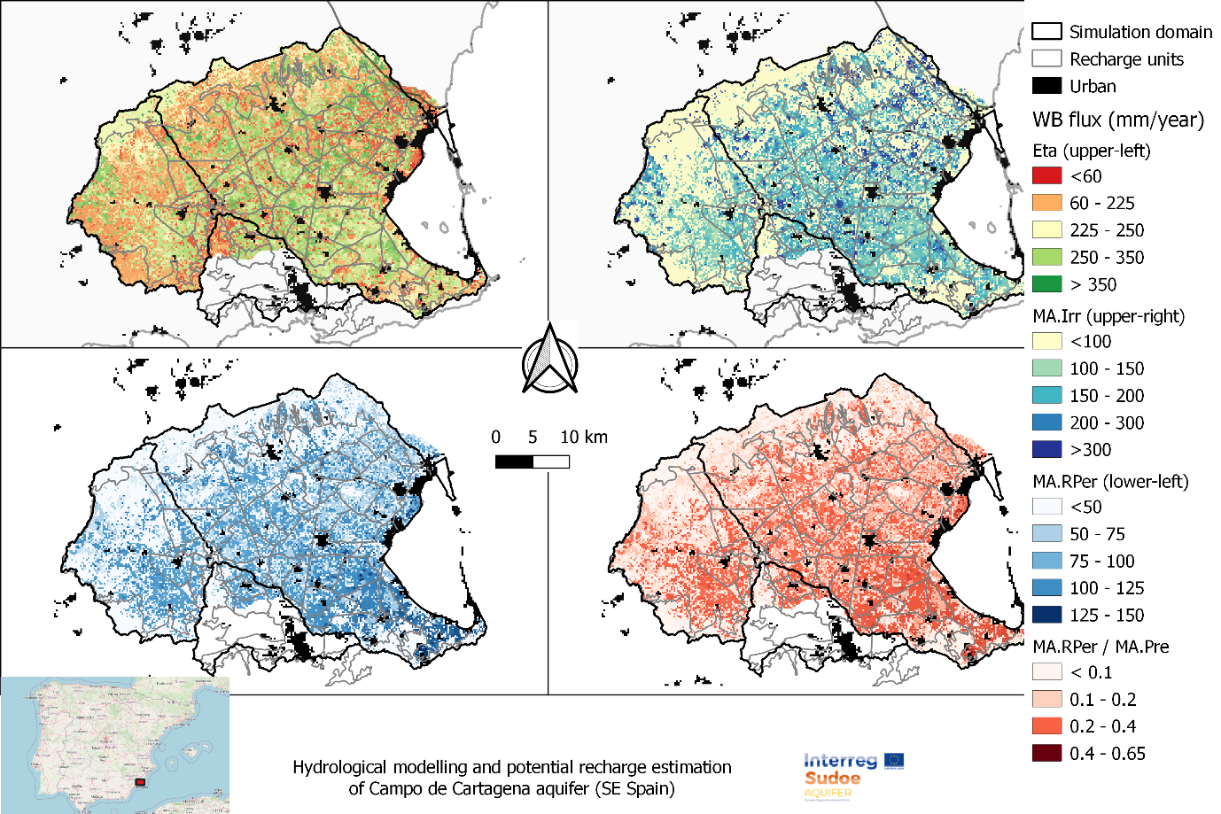
FutureWater expertise was required for providing a novel and open-source hydrological modelling framework able to quantify spatial patterns of daily root percolation as a direct surrogate of groundwater recharge in the Campo de Cartagena Quaternary Aquifer (CC-QA). This aquifer is located at SE Spain and is one of the most important vectors of water drainage to the Mar Menor lagoon.
This task is addressed through the improvement and local calibration of the SPHY code for the Campo de Cartagena and the simulation of the water balance in the soil root zone from the 1950s until the end 2020. The SPHY-Campo de Cartagena includes a new routine able to compute irrigation inputs at the pixel level based on satellite data. Timeseries of monthly root percolation are taken as good surrogates of potential groundwater recharge and used as the main forcing input to an hydrogeological model of the Quaternary aquifer. The calibration process is performed through a sensititivity-intercomparison analysis in which model-derived outputs (irrigation and streamflow) during the calibration period are cross-checked against actual observations.
Spatial patterns of root percolation and the relative contribution of irrigation return flows to the total groundwater recharge were quantified (e.g. Figure 1) under historical and current conditions. Simulation results would show the lack of a significant temporal trend in the long-term recharge rates in the aquifer, most likely due to the the strong interannual variability observed in rainfall patterns, but also by the trade-offs resulting from the combination of climate, land use and irrigation-crop management drivers.
Figure 1. Mean Annual values of the main water balance components in Campo de Cartagena (2000-2020). RPer_ratio refers to the fraction between Root Percolation (MA.RPer) and Precipitation (MA.Pre)
FutureWater supports Fiera Comox in its due diligence process for the acquisition of a vertically integrated tree-fruit operation in North Spain. Particularly, FutureWater addresses an overall assessment of the most important water-related factors of risk that may control the current and medium-term feasibility of the fruit orchard farming system of interest. The application of FutureWater’s approach applies a multicriteria analysis and allows to qualify the levels of risk for each key factor analyzed.
FutureWater’s approach rests on: 1) the collection and analysis of data retrieved from documents, large datasets, and in-situ field inspections and stakeholder interviews, and 2) the scoring of the risks previously identified based on a final expert judgment.
Key sources of information for this risk screening included:
Existing documentation, reports, plans, and local legislation that may affect the access to water for irrigation
Existing and publicly accessible spatial and GIS data, including satellite imagery and thematic datasets available through national and regional agencies and platforms (Ebro River Basin Authority, National Infrastructure of Geospatial Data, Spanish Information System of Water)
Meteorological data (rainfall and temperature) from nearby weather stations
Groundwater level from the Spanish National Ministry of Environment.
Private data and documents generated by clients and stakeholders through personal and follow-up communications with farmer
Key variables analyzed and evaluated at the district and regional scales, to the extent relevant to the farm, included:
Water availability of surface and groundwater resources. For groundwater, a trend analysis of water levels, and first-order assessment of quality constraints and risks is included.
Impacts of climate change on water resources availability based on rainfall and temperature trends and projections for the region.
Water quality for irrigation purposes.
Potential conflicts due to competition for water in agriculture and other sectors of activity.
Legislative and policy-related factors that may affect the overall performance were also analyzed risk-by-risk.
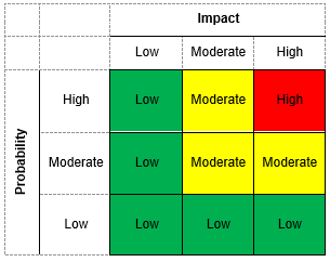
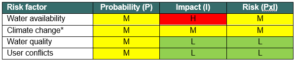
Four factors of risk were analyzed: water availability, climate change, water quality, and water conflict. Each factor of risk was scored according to a risk matrix in which levels of probability of occurrence and impact severity were qualified based on data and expert judgement. For each factor, a risk matrix with three levels of overall risk were adopted: Low Risk (L), Moderate Risk (M), and High Risk (H)
Figure 1. Overall risk levels when probability of occurrence and impact severity are qualified.Figure 2. Overview of risk assessment by factor.
In this particular project, the approach was implemented in four different settings located in the area.
Groundwater availability is critical to the Umbeluzi Catchment. Currently, there is a need for a simple tool that can asses the availability of resources in the ground.
This especially to asses the permits for groundwater extractions. It is expected that a simplified modelling approach can provide a trend analysis sufficient for the water authorities in Mozambique to perform assessments of the sub-surface water availability. Furthermore, the water availability will be assessed for current and future conditions, under different scenarios of climate change and demand increase.
Within the project, FutureWater will develop a groundwater model in WEAP, using the Strategic Model previously build for the Umbeluzi catchment. To this end a detailed data gathering activity will take place proceed by developing the model. We aim to validate and improve the model with measurements available of groundwater levels in the catchment. The model will be validated with the technical team of ARA-Sul. Ultimately, a dedicated training session for ARA-SUl will ensure that model operation is performed by local experts.
Eswatini’s development is at risk by natural drought hazards. Persistent drought is exacerbating the country’s existing challenges of food security and the ability to attain sustainable development. Therefore, FutureWater, Hydrologic, and Emanti Management joined forces to bring together technologies and complementary expertise to implement the GLOW service which includes: short-term and seasonal forecasts of water availability and demand, an alerting service when forecasted water demand is higher than water availability, and water distribution advisories to reduce impact and maximise water security for all water users.
The GLOW service will be piloted in the Maputo River and Mbuluzi River Basins where three-quarters of the population of Eswatini lives, which includes the Hawane dam that supplies water to Mbabane (Capital City of Eswatini) and which is the major water supply source for Maputo, a Delta city (1 million inhabitants) which suffers from water shortages. The main beneficiaries of this project are the Joint River Basin Authority (JBRAS-PB) and the 5 River Basin authorities, AraSul (Mozambique) and the Department of Water and Sanitation (South Africa).
The innovation of GLOW is bringing together proven and award-winning technologies of advanced earth observation, open data, high-performance computing, data-driven modelling, data science, machine learning, operations research, and stakeholder interaction. These technologies require minimum ground truth information, which makes them very scalable and applicable in poorly monitored environments throughout the world. The coherent combination of the technologies into one decision support service ensures the optimum division of water, basically distributing every drop of water to meet the demands of all interests present in large river catchments.
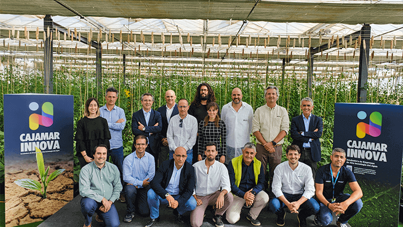
InfoSequia, the Drought and Early Warning System (DEWS) developed by FutureWater, was granted for being part of the Cajamar-INNOVA Incubation Programme powered by Cajamar Fundation.
InfoSequia has been granted by Cajamar-INNOVA, a High-Tech Incubator/Accelerator focused on the Water and Agro sector. During the 6-month granted period, FutureWater’s staff is being mentored and supported by experts on topics that cover technological and business aspects. Two main objectives have been planned: 1) to increase the technical readiness level of the service by testing its reliability and suitability for the private agrobusiness and agroinsurance sectors, and 2) to improve the business strategy by identifying market opportunities and reinforcing the communication with potential stakeholders and early adopters.
Since the beginning of the Programme, several campus have been organized to deal with specialized training workshops and promote synergies among the start-ups granted. Recently, in November 2020, a campus session was also organized in parallel with the DATAGRI 2022 Forum held in El Ejido (Almería, Spain). During one-day field visit at Experimental Research & Innovation Center of Las Palmerillas-Cajamar, our colleagues Amelia Fernández and Sergio Contreras introduced InfoSequia to the participants of the event.
InfoSequia is currently part of the HERMANA system of the Cauca Valley Basin (CVC) in Colombia. Nowdays, the impact-based forecasting capabilities of the service are being tested in two pilot regions in Mozambique and Spain. These activities are also being supported by the Incubed Programme funded by the European Space Agency.
More information about the project can be found here.
Cajamar-INNOVA incubation programme participants
Early September at the Global Gravity-based Groundwater Product (G3P) General Assembly in Zurich, FutureWater, along with 11 other consortium partners, gathered to present scientific results, project milestones, and discuss the way forward. For context, the G3P product monitors groundwater storage changes with global coverage at a monthly resolution (2002 – present) through a cross-cutting combination of GRACE and GRACE-FO satellite data. The product is being developed for operational implementation of the Essential Climate Variable (ECV) Groundwater into the Copernicus Climate Change Service.
As part of the project, FutureWater is responsible for validating the G3P product against in-situ groundwater observations in continental Spain (at pixel level) as well as use it to calibrate a Groundwater Drought Index and integrate it into InfoSequia which is FutureWater’s in-house Drought Early Warning System.
From FutureWater, Tania Imran presented the research findings from the validation case study in Spain while Sergio Contreras shared the technical workflow for the ingestion of the G3P product in InfoSequia. Different statistical metrics were adopted to assess the correlation between the GRACE-groundwater storage anomalies and in-situ groundwater index. Cross-correlations, obtained at 0.5-degree resolution, were presented followed by a discussion on the spatial patterns observed and the potential influence of local hydro(geo)logical conditions on the results.
As the groundwater storage anomaly is derived by accounting for changes in glaciers, snow, soil moisture and surface water, other consortium partners responsible for developing these accounts also shared insights on the most optimal approach to compute water storage variations in such compartments.
Since the project is now in its concluding phase, FutureWater is condensing the research findings in a report that will highlight the performance of G3P in continental Spain and show how the product can refine drought early warning systems.