Concept
Om de ecologische en sociaaleconomische duurzaamheid van semi-aride regio’s in de wereld te verzekeren onder klimaat- en landgebruiksveranderingen en meer terugkerende en intense droogtes, hebben we instrumenten nodig die in staat zijn om: a) te anticiperen op het begin van droogtes en waterschaarste en vroegtijdige waarschuwingen te geven; en b) essentiële informatie te verstrekken over hoe betrokkenen de potentiële gevolgen effectief kunnen beheren en verzachten.
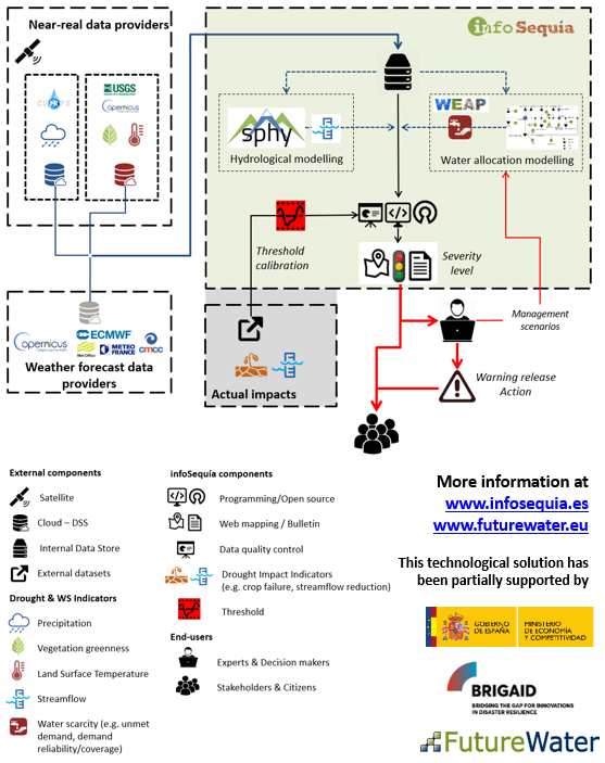
InfoSequía is een toolbox voor monitoring en effectbeoordeling van droogte die duidelijke en up-to-date gegevens en waarschuwingen biedt over de droogtestatus van een regio en de ernst en ruimtelijke omvang van de effecten ervan. InfoSequía wordt aangeboden als een site- en gebruikersspecifieke IT-toolbox op maat, met een flexibele en modulaire architectuur geïntegreerd met tools voor:
- De detectie, monitoring en bewaking van droogteperiodes op basis van satellietgegevens en gegevens van sociale media;
- De voorspelling en ruimtelijke analyse van de potentiële hydrologische effecten, en
- Ondersteuning van gebruikers en besluitvormers bij de efficiëntere beheerstrategieën die beschikbaar zijn om de gevolgen van droogte te beperken.
InfoSequía-output wordt geleverd via pdf-bulletins of een webmapping-app van waaruit alle gegevens interactief kunnen worden opgevraagd en gedownload. Vanwege de flexibiliteit en schaalbare architectuur kan InfoSequía gemakkelijk worden geïntegreerd in andere systemen voor vroegtijdige waarschuwing voor droogte of controle-/informatiecentra.
FutureWater-toepassingen
De componenten van InfoSequía zijn ontwikkeld door FutureWater en getest gedurende meer dan 5 jaar onder gesimuleerde en operationele omstandigheden. Het heeft een gevalideerde TRL8
Potentiële begunstigden en eindgebruikers van InfoSequía zijn:
- Waterschappen en regionale milieuautoriteiten (voor bv. droogtemonitoring)
- Bosbouw- en brandrisicomanagers (voor bv. brandrisicobewaking)
- Verenigingen en landbouworganisaties (voor bv. effecten op de opbrengst van gewassen, risicobeoordeling van de waterallocatie en prognoses van droogte)
- Verzekeringsmaatschappijen (voor bv. indirecte indexverzekeringsproducten)
Gerelateerde projecten
-
Megadroughts in the water towers of Europe – from process understanding to strategies for management and adaptation
Megadroughts are rare and poorly understood hazards. They are defined as exceptionally severe, multi-year, prolonged (>5 years) periods of drought that impact severely large areas and different sectors of the economy and the environment (Cook et al., 2022). They are generally caused by the concurrence of extreme events of dryness...
-
GLOW: Global Water Availability Forecasting Service to Support Water Security
The GLOW project aims to pilot an operational service that provides timely and easy access to current and forecasted water availability and demand across the entire Maputo River and the Black Umbeluzi River Basins.
-
InfoSequia-4CAST: Forecasting and Quantifying Risks of Crop and Water Supply Failures Using Machine Learning and Remote Sensing
InfoSequia-4CAST combines historical and up-to-date observations of satellite-based meteorological and agricultural drought indices with climate variability indices, to generate seasonal outlooks of water supply and crop yield failure alerts. These impact-based indicators are computed using a simple, robust and easily understandable statistical forecasting-modelling framework. By making use of multi-sensor, state-of-the...
-
G3P: Development of a Global Gravity-based Groundwater Product
Groundwater is one of the most important freshwater resources for mankind and for ecosystems, and has been declared as an Essential Climate Variable (ECV) by GCOS, the Global Climate Observing System. However, the Copernicus Services do not yet deliver data on this fundamental resource, nor is there any other data...
-
TWIGA: Transforming Weather Water data into value-added Information services for sustainable Growth in Africa
TWIGA aims to provide actionable geo-information on weather, water, and climate in Africa through innovative combinations of new in situ sensors and satellite-based geo-data. With the foreseen new services, TWIGA expects to reach twelve million people within the four years of the project, based on sustainable business models. The TWIGA...
-
HERMANA: Tool for Integrated Water Management
HERMANA aims to foster the development of an integrated water management decision support system (DSS) that supports daily, tactical and strategic decision-making related to water resources in Colombia, and specifically in the Cauca Valley Basin. The HERMANA tool will be a comprehensive system able to provide valuable, relevant, and reliable...
-
DRR: Technical Assistance on Drought Information and Early Warning Systems
To address the recent drought problems in Bolivia, FutureWater and Deltares have been asked to provide recommendations on drought early warning and drought information systems, both on technical aspects as well as on institutional issues. The Dutch Risk Reduction Team has held stakeholder consultations with the Ministry of Environment and...
-
IMPREX: IMproving PRedictions and management of hydrological EXtremes
FutureWater leads the coordination of the “Agriculture and Drought” sectoral Work Package of IMPREX. This WP specifically aims to study and evaluate the use of IMPREX weather forecasts and predictions, climate variability, and drought indicators to assess agricultural drought risk and impacts over four case studies and at the pan-European...
-
Bodemvochtgegevens ter ondersteuning van Leverbot analyses
De Gezondheidsdienst voor Dieren (GD) heeft in de afgelopen jaren een analyse van leverbotbesmettingen uitgevoerd. Dit onderzoek heeft laten zien dat verschillende omgevingsfactoren een rol spelen zoals grondwaterstand, neerslag, temperatuur en bodemtype. Daarnaast is op basis van landsdekkende bodemvochtschattingen door FutureWater vastgesteld dat ook bodemvocht en leverbotbesmettingen gecorreleerd zijn, wat...


