Concept
As technology progresses, satellites increasingly offer a reliable source of spatially distributed information on a variety of environmental variables. By using the reflective properties of the earth’s surface and atmosphere, it is possible to monitor (among others) vegetative cover, rainfall, snow cover, land surface temperature and actual evapotranspiration through time. Sensors like Landsat ETM, MODIS, PROBA-V and Sentinel offer a range of options on different spatial and temporal scales. FutureWater makes use of open-access datasets in consultancy studies, for operational decision support systems, and for feeding, calibrating and validating hydrological models.
Satellites now provide an archive of imagery that covers multiple decades. These historical records allow us to identify trends and spatial patterns in different factors associated with water resource management, such as water supply, water consumption and crop growth. Land cover changes, such as deforestation and agricultural expansion, can be mapped and quantified in assessments of ecosystem services and land degradation. By using state-of-the-art tools like the Google Earth Engine, we analyze these trends and patterns to support policy makers in identifying appropriate measures at different locations in their area of interest. In addition, FutureWater sees satellite-derived datasets as essential in maximizing the quality of output of simulation models to support decision makers, particularly in data-scarce areas.
Although satellites can only provide information on the past situation, a smart combination of remote sensing and simulation modeling provides an integrated outlook on historical, current and future water availability. Governments, basin authorities, farmers and hydropower companies are interested in anticipating on future events by taking timely and targeted measures. Feeding hydrological models with the most recent satellite images in an operational context allows the construction of short-term forecast based on the actual current conditions. A number of satellites pass over quite frequently, making their data especially useful for operational decision support systems. We collect these data as soon as they come available, process them using our models, and disseminate the resulting information to the end user of the system. Up-to-date satellite-derived images provide insight in the actual conditions related to water resources and vegetation, without having to visit the field.
FutureWater applications
In most of our projects, FutureWater makes use of satellite remote sensing for one or more of the purposes described above. Some examples are given below.
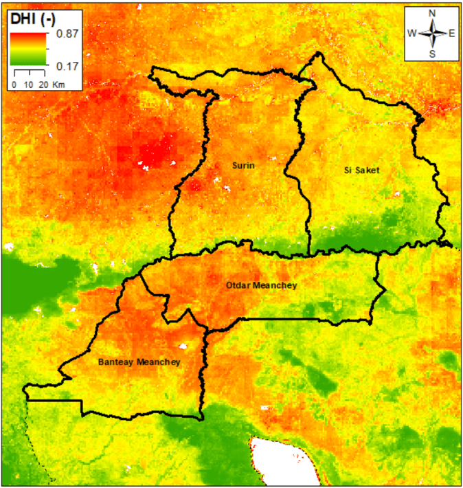
FutureWater has developed the Drought Monitoring and Impact Assessment Toolbox (DMIAT) for characterizing drought-prone areas in terms of drought hazard, vulnerability, and risk, as well as evaluating impacts of a specific drought event. The image presents the integrated Drought Hazard Index for two provinces in Cambodia and two in Thailand; the result of an extensive remote sensing-based analysis involving spatial rainfall statistics, vegetation cover statistics, and land surface temperature. More information on the project can be found here.
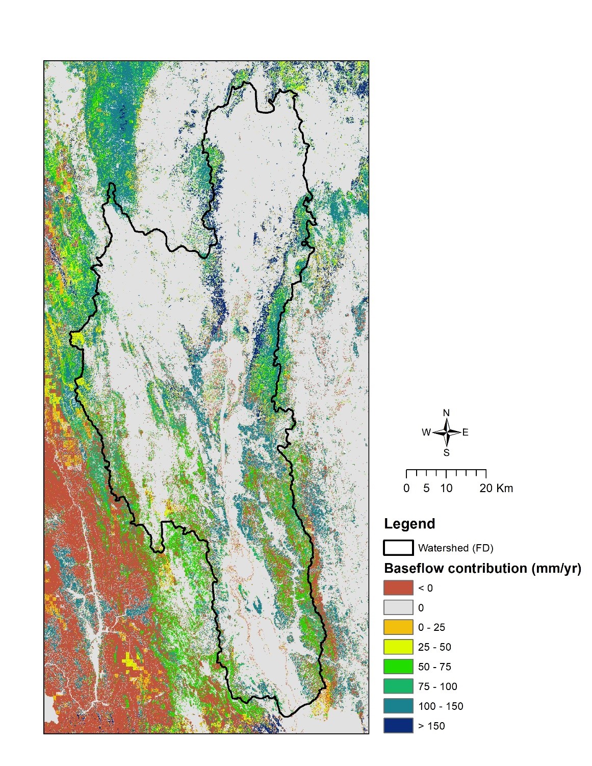
FutureWater uses remote sensing in assessments of ecosystem services, particularly those related to water (see the white paper on this topic led by FutureWater). Satellite data can be integrated with simulation models to quantify ecosystem services, such as the contribution of water during the dry season. The map shows the watershed of Inle Lake in Myanmar, an area where dry season water supply is highly important to maintain lake levels, provide water for domestic and agricultural consumption, and support production of hydropower. By integrating different sources of satellite data and the InVEST ecosystem services model, FutureWater mapped the ecosystem services in the Inle Lake region to support decision making on nature conservation policies by a newly created basin management authority. More information on the project can be found here.
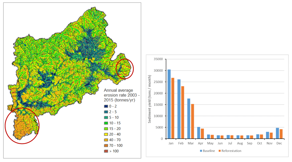
Combining remote sensing data with simulation models can also support Sustainable Land Management (SLM) strategies. In areas with scarcely available field data, satellites are often the only available source to provide up-to-date, spatially disaggregated data. The map on the left shows the annual average erosion rate for the Bealanana catchment in Madagascar as produced on a daily basis by the SPHY model. The high level of spatial detail of this map is made possible by the integration of satellite-derived datasets on vegetation dynamics, land cover and terrain. With a reliable simulation model, validated among others by satellite-derived evapotranspiration data, it is possible to run differen SLM scenarios and evaluate the impact on erosion and sediment yield of e.g. reforestation, agroforestry, and terracing measures. More information on the project can be found here.


